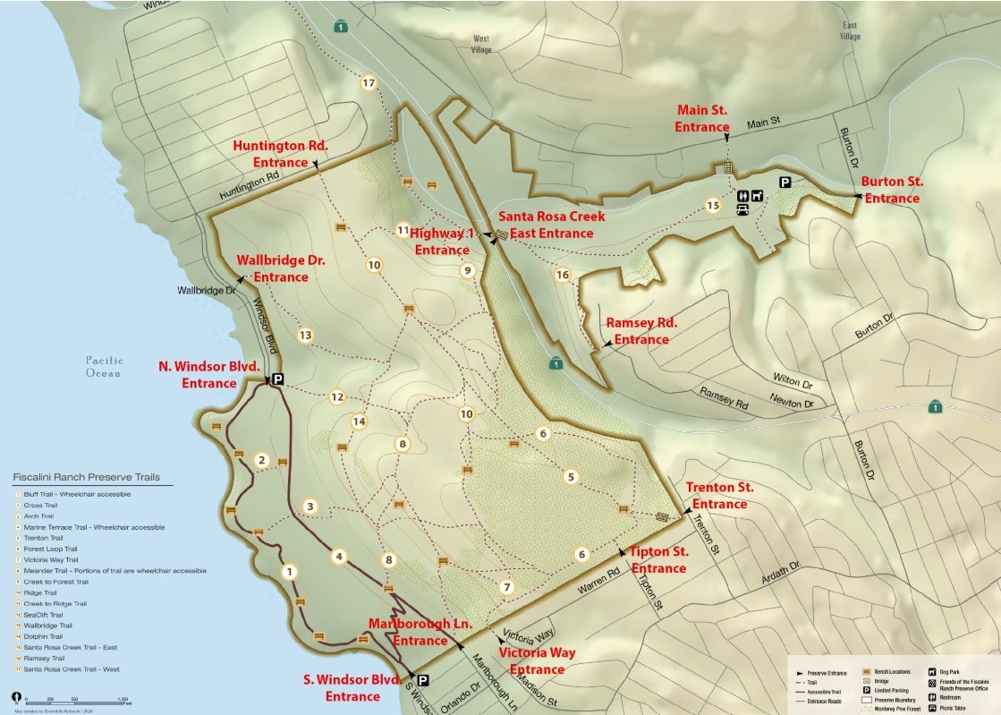
Trails
Fiscalini Ranch Preserve is open every day from dawn to dusk, and it’s free to visit.
Fiscalini Ranch Preserve is home to miles of scenic walking trails that take you through a variety of breathtaking landscapes. Stroll along the dramatic coastline, wander through rolling coastal prairie, pass by seasonal wetlands, and explore the majestic Monterey pine and oak forests. Whether you're looking for a peaceful nature walk or a place to spot wildlife, the Ranch offers something for everyone.
Our trail map highlights all designated entrances and trails, making it easy for visitors to navigate and enjoy the preserve. Plan your next outdoor adventure and experience the natural beauty of Fiscalini Ranch.
West Fiscalini Ranch Preserve Trails
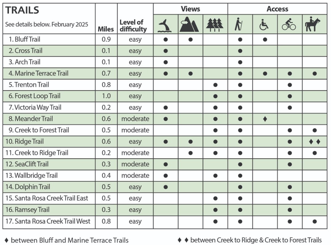
1. Bluff Trail - 0.9 miles
A breathtaking walk along the coastal bluff, this trail features a mix of boardwalk and gravel paths. It’s part of the 1,100-mile California Coastal Trail System and includes handcrafted benches for resting. Hiker and ADA accessible. No bicycles.
4. Marine Terrace Trail - 0.7 miles
A level trail that runs between rolling grasslands with stunning ocean and mountain views. Rustic stone benches provide perfect spots to take in the scenery. Hiker, bicycle, and ADA accessible.
5. Trenton Trail - 0.8 miles
A peaceful walk through a pine and oak forest, crossing a rustic bridge over a seasonal creek. Connects to the Ridge and Forest Loop Trails.
6. Forest Loop Trail - 1.0 mile
A winding trail through 70 acres of native Monterey pines and coast live oaks, offering a true forest experience.
8. Meander Trail - 0.6 miles
Following the forest’s edge, this trail offers seasonal wildflowers, grasslands, and ocean views. A lower section includes an ADA-accessible boardwalk linking the Bluff and Marine Terrace Trails. Moderate elevation change on the upper trail.
Agreement Between the CCSD and the Friends of the Fiscalini Ranch Preserve Regarding the Fiscalini Ranch Linking Boardwalk Project9. Creek to Forest Trail - 0.5 miles
A moderate climb from the Santa Rosa Creek entrance, winding through a peaceful mixed oak and pine forest to connect with the Forest Loop Trail.
10. Ridge Trail - 0.6 miles
This scenic trail follows a 200-foot ridge, offering stunning views of the Monterey National Marine Sanctuary to the west and the Santa Lucia mountain range to the east.
11. Creek to Ridge Trail - 0.2 miles
A short but scenic climb past original ranch foundations, connecting to the Ridge Trail. Moderate elevation change.
12. SeaClift Trail - 0.3 miles
Starting at the north Windsor Avenue entrance, this trail leads uphill through grasslands and past a seasonal creek. Connects to the Meander or Dolphin Trails. Moderate elevation change.
13. Wallbridge Trail - 0.4 miles
A gentle path overlooking a seasonal creek with ocean views, connecting to the Dolphin Trail.
14. Dolphin Trail - 0.5 miles
This trail winds uphill through rolling grasslands to the Ridge Trail, lined by large Cypress trees with stunning Pacific views. Moderate elevation change.
17. Santa Rosa Creek Trail - West - 0.8 miles
A shady trail along the creek, passing by historic ranch foundations. Home to steelhead trout and lush riparian habitat.
East Fiscalini Ranch Preserve Trails
15. Santa Rosa Creek Trail - East - 0.5 miles
A peaceful, flat trail through seasonal wetlands and open grasslands, nestled between a forest hillside and Santa Rosa Creek.
Dog Park
Located at Rodeo Grounds Road off Burton Drive, this off-leash dog park has separate sections for large and small dogs. A great spot for pups to run and play.
Bicycle Trails Guidelines & Maps